9. Surface cut/fill volumetrics
In this section:
Introduction
The command Surface cut/fill volumetrics calculates the cut and fill volumes between two surfaces or between a surface and a polygon data set representing the theoretical terrain.
The cut volume can be seen as the volume to be dredged (positive volume), whereas the fill volume is the volume to be filled (negative volume).
The command reports the volume and the area (horizontal projection) of the cut and fill volume in a text item.
In addition this command can produce the following products:
- Cut surface
- Difference surface
- Terrain with cut
- Terrain with fill
- Terrain with cut and fill
- Cut area
- Fill area
The content of the menu
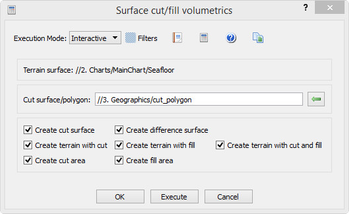
The Surface cut/fill volumetrics dialog with input polygon data.
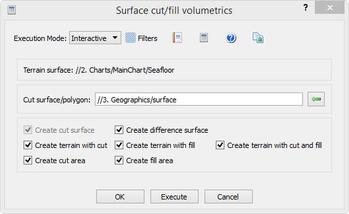
The Surface cut/fill volumetrics dialog with input surface data.
Terrain Surface
The Terrain surface part gives information of which surface the command is started from. This is the surface which will be cut during the volumetrics calculation.
The original surface itself will not be manipulated, just copied.
Cut surface/polygon
In the Cut surface/polygon part the gives information of which surface the command is started from. Select a Poly Data or Structured Points (surface) data set in the project and click the ![]() button beside the text field.
button beside the text field.
When starting the volumetrics with a Poly Data set as input, the poly data will be triangulated to a surface model. The better the polygon describes the actual cut surface the better the result the volumetrics calculation will be. The surface created from the poly data is named as the Cut surface.
The calculation of the volumes is done by subtracting the cut surface from the Terrain surface to get the difference surface.
Create cut surface
Create the cut surface from polygon data set.
The surface is saved with the name CutSurface in a subfolder named Volumetrics in the same folder as the terrain surface is located.
Create difference surface
The difference surface is the Terrain surface minus Cut surface.
The surface is saved with the name DifferenceSurface in a subfolder named Volumetrics in the same folder as the terrain surface is located.
Create terrain with cut
What the terrain would look like if the parts of the terrain that is higher than the cut surface was replaced by the cut surface.
The surface is saved with the name TerrainWithCut in a subfolder named Volumetrics in the same folder as the terrain surface is located.
Create terrain with fill
What the terrain would look like if the parts of the terrain that is deeper the cut surface was replaced by the cut surface.
The surface is saved with the name TerrainWithFill in a subfolder named Volumetrics in the same folder as the terrain surface is located.
Create terrain with cut and fill
What the terrain would look like if the parts of the terrain was replaced by the cut surface where both have defined areas.
The surface is saved with the name TerrainWithCutAndFill in a subfolder named Volumetrics in the same folder as the terrain surface is located.
Create cut area
Horizontal projection (z=0) showing those parts of the terrain surface that would be cut.
The surface is saved with the name CutArea in a subfolder named Volumetrics in the same folder as the terrain surface is located.
Create fill area
Horizontal projection (z=0) showing those parts of the terrain surface that would be filled.
The surface is saved with the name FillArea in a subfolder named Volumetrics in the same folder as the terrain surface is located.
Note: Earlier version of the created surfaces will be kept. Surfaces from the latest run will be saved in a Volumetrics folder with a unique name, like Volumetrics (1) etc.
The Results
After executing the volumetrics a dialog will pop up showing the parameters, result and volumes from the calculations. The report itself is saved in the project structure in the folder named Reports located in the same folder as the terrain surface. The report itself is named as YYYYMMDD HHMMSS Surface cut/fill volumetrics (the name of the executed command).
All reports from all runs will be saved in the Reports folder.