Maritime Lines
- Erlend Kvinnesland
- Jon Mugaas
- Anders Moe
- Harald Sund (Unlicensed)
Introduction
Official lines of jurisdiction can be imported into Geocap. See the import chapter for more about this. These lines can be displayed and used as a basis for further calculation in Geocap. If such lines do not exist, Geocap can produce lines from a line describing the coastline.
Note that our Maritime Zones plugin extends the Shelf package with additional capabilities for calculating maritime zones.
It works directly with ArcGIS feature classes and can calculate any maritime zone from both normal and straight baselines.
The calculation also extracts critical points for each zone and store them in a feature class. Read more about the Maritime Zones plugin
In this section:
Baseline
A baseline can be created in Geocap by digitizing points on existing data. It could be based on a set of coordinates describing the coast line, or on a geo referenced nautical charts imported into Geocap as images. Another alternative is to use a data set describing the coastline directly as a baseline. Using this line for a distance calculation may however be more time consuming than when using a proper baseline, as the coastline data sets often contain a lot more points than a baseline.
Generating distance lines (12M, 24M, 200M, 350M etc.)
For FOS+60M lines see: The Foot Of Slope (FOS)
Maritime lines are defined by a distance to the baseline. These lines can be generated by running one of the commands, Generate xx, placed on the baseline schema.
When running the command, you are presented with the following command editor:
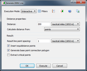
The command for generating a distance line
Distance properties
Distance & unit
The default distance and unit will be based on the command you choose. The image above shows the Generate 200M Line and the settings are of course set to 200 and nautical miles. You can however specify any distance and unit you want.
Points or lines
You can also select if you only want to calculate distances from the input points, or if you want to calculate distances from the lines between the points as well. If you select lines, the input lines will be re sampled (in the coordinate system you are currently using), and points on the line will be used as input to the algorithm as well. This will not give the same result as the method of tracés parallèles . The result line will be equal to the result of an envelopes of arcs calculation of the input points.
Distance calculation Method
There are several calculation methods available with different accuracy. We always recommend using the Vincenty Calculation.
Result line
Point spacing
You can specify the distance between points on the resulting line. The default is set to 1 nautical mile for 200M and 350M lines, but you might consider reducing the spacing to 0.5 nautical miles.
Insert equidistance points
The equidistance point is the crossing points between two arcs in an envelope of arcs calculation. These points are the turning points of the distance line.
Basepoint connection
By checking Generate basepoint connection polygon you will get a dataset which shows polygons pointing back to the critical basepoints that contributed to the distance line.
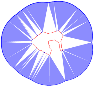
Basepoint connection polygon
When executing the command the new line will be placed in a folder in the Maritime lines folder i.e. 1. Maitime lines / 200M lines
Midlines and tri-point calculations
Geocap can calculate midlines between two or more countries. The command Generate midline can be found on the baseline schema.
Calculation Area
The midline will be generated inside calculation area. This area has to be set before you execute the command.
- Scale to input - will compute the midline in a bounding box containing all the input datasets.
- Scale to active window - will scale to your active window
- Specify - lets you manually define a calculation area either by typing in values, or by using Rubberband select.
Base point weights
Midlines can be weighted by putting weights on the base line points. The weights should be stored as point field data on the base line datasets with the name "Weight". The weights will only be used if the checkbox use base point weights is checked. A base line without weights will get a default weight of 1.0 for all base points.
Base point connection polygons
By checking Generate basepoint connection polygon you will get a dataset which shows polygons pointing back to the critical basepoints that contributed to the midline.
Tri-point
A Tri-point is a point on the mid-line which has an equal distance to three base points. These are the turning points of the midline. Geocap will automatically detect the tri points and include them in the midline. You can get information about the tri-points in the table view of the midline. The table has columns with distances, an accuracy estimate, and information about which base points are used in the mid-point and tri-point calculation.
Metadata
By opening the table view for a distance line you can see which baseline it was generated from. For each point on the distance line you will see a reference to the point in the baseline which contributed to that point.
For equidistant points you will see reference to the two points on the baseline which contributed to that point.
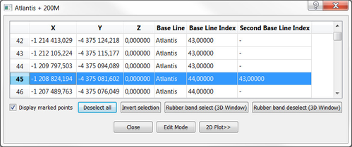
200M line table view