Geocap 6.5 Release Notes
About this release
Release Date
11.12.2013
Updated releases
Release distribution
Geocap 6.5 is available from http://www.geocap.no/downloads to all clients under paid maintenance agreement.
Please note that you will need a user account to access this page. If you do not already have one, send an email to: support@geocap.no
Licensing
If you are running the Geocap 6.4 version you do not need a new license file in order to run Geocap 6.5.
You have to do the following before starting Geocap 6.5 for the first time:
- Start > All Programs > Geocap > Geocap-6.5 > Licensing and right-click Initialize, then click Run as Administrator.
Supported operating systems
Operating system | System type |
|---|---|
| Windows 8 | 64bit and 32bit |
Windows 7 | 64bit and 32bit |
Windows Vista | 64bit and 32bit |
Windows XP | 64bit and 32bit |
Geocap 6.5 is currently not available for Linux or Unix, contact support@geocap.no if you want more information on this.
Both 32bit and 64bit versions of Geocap 6.5 are available on our download page. Make sure to download the correct one.
Consult this Microsoft support page to figure out which system type your are running on. (Or you may try Properties on Computer)
Project upgrade
All projects opened in Geocap 6.5 will all be irreversibly converted to a new project format. We highly recommend that you back up your projects prior to opening them in Geocap 6.5.
Some highlights in Geocap 6.5
1. Maritime Zones plugin
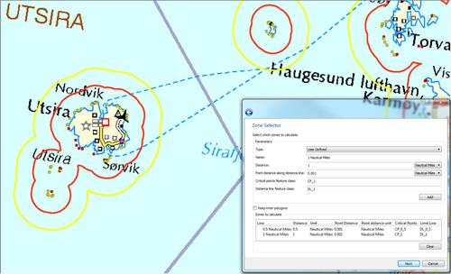
The Maritime Zones plugin available with Geocap 6.5 extends the Shelf package with additional capabilities for calculating maritime zones:
- The plugin works directly with ArcGIS feature classes and sits on top of the Datalink for ArcGIS plugin. It uses the familiar ArcGIS Table of Contents, ArcMap 2D view and toolbars found in ArcGIS desktop.
- It provides an easy to use wizard that lets you setup calculation parameters for the 12NM, 24NM and 200NM distance lines. You can also calculate arbitrary distances.
- The calculation takes into account straight baselines if these are attributes in the feature class
- The results are stored as new feature classes and be efficiently examined using the embedded ArcGIS tools or saved as a mxd map document for further processing in ArcGIS.
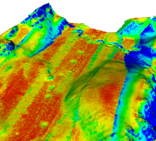
2. Improvements in Gridding
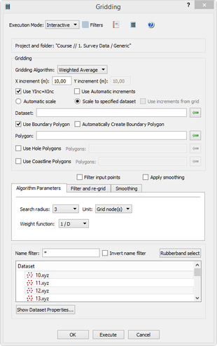
A new gridding command has been made available on generic folders which makes it possible to create surfaces from multiple datasets in a folder.
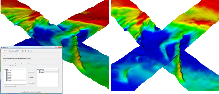
Left: before merge. Right: after merge.
It is also possible to merge multiple grids into one large grid. Grids with different resolutions can also be merged together.
3. DataLink for ArcGIS
The Datalink for ArcGIS plugin provides interoperability between Geocap and the ArcGIS suite of products from Esri.
Key features include:
- Read and write access to almost all Esri dataformats, including ArcGIS Servers and WMS
- Read basemaps from ArcGIS online
- Load ESRI dataformats like geodatabases, map documents (*.mxd), shape files and rasters.
- Includes GUI elements from the ArcGIS suite of desktop products like table of contents, ArcMap 2D view and toolbars.
- Examine features, attributes and dataset properties.
- Create and embedd Esri geodatabases from within the Geocap project manager.
- Drag and drop Geocap data into a geodatabase connection and ArcGIS Table of Contents.
- Supports workflows that let you transfer Geocap project data to ArcGIS formats.
4. Support for BAG
Geocap Seafloor now support BAG export. A standard export format for grids which is also supported by ArcGIS
An exported file will contain the layers Elevation and Uncertainty. The vertical depth reference is automatically set to MSL (Mean Sea Level)
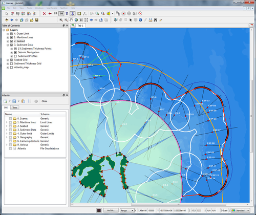
5. New module: Ground Model
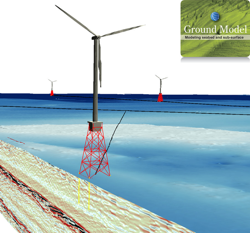
With Geocap 6.5 we have released a new module called Ground Model.
This module enables the integration of water column, ground / seabed, infrastructure and sub-surface data, including seismic and boreholes, in a single 3D environment, with processing and interpretation capability.
You can read more about this module on our product website.
 General
Navigation
- It is now possible to pan using the keyboard arrows
Seismic
- The scaler value: 0.0000002778 has been added as an option for converting coordinates in seconds of arc to decimal degrees
- Fixed error where it was not possible to select a seimic line in the interpretation system
- Several other minor improvements in seismic interpretation
- SEG-Y import now gives a warning when the Advanced option is used
- It is now possible to extract iHorizons to polydata
Graphics
- Point cloud data is now updated in the graphics window after running the function command
- Graphic is now updated after using edit mode in Table View
- LOD point now works with polydata with double precision coordinates
- Rubber band now selects point correctly
Scripted commands
- Fixed error where function command would not run on polydata
- Improvement in setpoints command
Help
- Help > About Geocap now contains more information about OS, Memory and Graphics card.
 Seafloor
Gridding
Changes in the Gridding command
- All algorithms can use boundary polygon.
- New parabolic gridding algorithm for points and multibeam data
- New Multilevel B-Spline algorithm for single beam data.
- The commands gridding files/multibeam data now can browse in boundary polygon.
- The grid area can be defined from the size of another data set (points, polygons, grid).
- Statistical Binning now updates history tab with details from the gridding report.
Export Multibeam Data
- The command Export Multibeam Data can export backscatter to ascii files.
Export to BAG (Bathymetry Attributed Grid)
- The export to BAG is implemented. This format is a standard for grids and is also supported by ArcGIS.
- The file contains the layers Elevation and Uncertainty. The vertical depth reference is automatically set to MSL (Mean Sea Level).
Points Classification
The command Points Classification speeded up:
- The removal of points within the radius for Shoals and Deep points is made faster.
- The selection of points from Soundings is rewritten from searching through the whole dataset to use a binary tree instead. The selected point is maximum half the grid increment away from the grid node.
- More tests on if the Cancel button is clicked. It is possible to abort processings taking long time.
Single Beam folder
The Single Beam folder has got two new commands:
- Display Soundings
- Revert flagged points. This commands can un-delete points removed by the point cloud editor.
XYZ data (Soundings) folder
The XYZ data (Soundings) folder has got the new command:
- Revert flagged points. This commands can un-delete points removed by the point cloud editor.
 Shelf
Shelf
1% sediment thickness calculation
- 1% sediment thickness calculation now works on sediment profiles which has been combined into one dataset.
Foot of Slope
- Fixed issue where Analysis Panel would not open because of missing plot items.
- The red FOS marker line in 3D is extended downwards to indicate FOS position on seismic lines.
- Display FOS points on bathymetric folders now display points using sphere marker.
- Fixed issues where sphere marker was not properly displayed for FOS points.
- Calculation interval lines are now plotted on top of any other plot items.
- You will now get a message if you select an interval where Geocap can not identify a FOS point.
 Oil & Gas
Graphics
- Improved visualization of seismic brick and surfaces
Seismic
- Fixed problem with SEG-Y export
Wells
- You will now get a warning if you try to import a well that already exist.
- LAS import now recognizes KB elevation
- New schema: "Time Depth"
- It is now possible to import logs on an existing well.
- It is now possible to view original log values on the properties menu or in the table view.
Well Tops
- A new system for handling well tops has been implemented
- Well tops can be imported from an ascii file into a Well Top folder
- Well tops can be edited an matched to wells