R. Surface Volumetrics
- Tore Sannes (Unlicensed)
Introduction
In Seafloor there is a lot of functionality to create more results and analysis. Some of the functionality mentioned in this section is started from the Seafloor Main Menu, or from the Charts folder, or from a specific data type, like Structured Points.
Exercises
Surface Volumetrics
The command Surface cut/fill volumetrics calculates the cut and fill volumes between two surfaces or between a surface and a polygon data set representing the theoretical terrain.
The cut volume can be seen as the volume to be dredged (positive volume), whereas the fill volume is the volume to be filled (negative volume).
The command reports the volume and the area (horizontal projection) of the cut and fill volume in a text item.
In addition this command can produce the following products:
- Cut surface
- Difference surface
- Terrain with cut
- Terrain with fill
- Terrain with cut and fill
- Cut area
- Fill area
Surface Volumetrics
- First use the Quick Digitizer to create a closed polygon where the volume is to be calculated. It is also possible to import the polygon from a disk file. Use the underwater shoal in the MainChart as the feature to volume calculate.
- Create the polygon in the MainChart folder by New > Workspace Data > digitized_line. Rename the polygon to the name digitized_closed_polygon.
- It is possible to diqitize the polygon with a depth value, but the depth value can also be assigned by the Polydata Function command. From the item digitized_closed_polygon, select All Commands > Shared Commands > Operations > Polydata Function... . Set function z = 60 and click Execute.
- Rename the new polygon to digitized_closed_polygon (60m).
- From the Seafloor icon in the MainChart folder, click Surface cut/fill volumetrics.
- In theSurface cut/fill volumetrics dialog, insert the digitized_closed_polygon (60m) into the Cut surface/polygon input field. (Mark in the project and then use the green arrow to the right.)
- Turn on the options Create cut surface, Create terrain with cut and Create terrain with cut and fill.
- Click Execute.
- The results from the volume calculation is presented in the Report menu. In the MainChart folder a new folder Volumetrics is created containing the produced data sets, CutSurface, TerrainwithCut and TerrainWithCutAndFill.
- Display the datasets and the polygon to see the difference.
- Change the depth level for the polygon to 70, as in the steps 3 and 4, and repeat the steps 6 to 10.
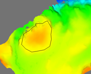
The actual surface and the digitized closed polygon.
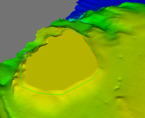
The cut surface and the digitized closed polygon at level 60 m.
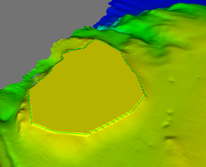
The terrain with cut and fill and the closed polygon.