/
P. Points Classification
P. Points Classification
- Erlend Kvinnesland
- Tore Sannes (Unlicensed)
- Harald Sund (Unlicensed)
Owned by Erlend Kvinnesland
Last updated: Oct 21, 2015 by Tore Sannes (Unlicensed)
Introduction
Seafloor can automatically classify points into the following categories:
- Shoals
- Deeps
- Ridges
- Saddles
- Valleys
The user can specify the search radius and angle, where applicable. The points will be saved as separate datasets in a classification folder under each chart.
This exercise expects that the project already contains at least one chart and a corresponding Seafloor surface.
Exercises
Exercise
Classify points
- On the Utilities (2) tab in the Seafloor Main Menu, click Point Classification.
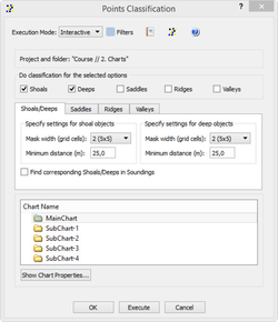
- Check the box for Shoals and the box for Deeps.
- Note all the boxes for the different classification types.
- Specify the search radius, for instance 50, in the corresponding tabs for the two data types.
- Select the main chart.
- Click Execute.
The resulting datasets can be found in the classification folder under the chart.
Exercise
Display classified points
- Browse to the classification folder for the actual chart.
- Display the dataset shoals_50 by right click and select Display Points.
- Display the dataset deeps_50 by right click and select Display Points.
Repeat the last excercise by changing the search radius. Also try to check the box Find corresponding points in Soundings.
, multiple selections available,
Related content
Points Classification
Points Classification
More like this
Q. Statistical Point Reduction
Q. Statistical Point Reduction
More like this
Seafloor
Seafloor
More like this
O. Chart Utilities
O. Chart Utilities
More like this
Seafloor Tutorial
Seafloor Tutorial
More like this
A. Getting Started with Geocap Seafloor
A. Getting Started with Geocap Seafloor
More like this